Introduction to NASA City Lights
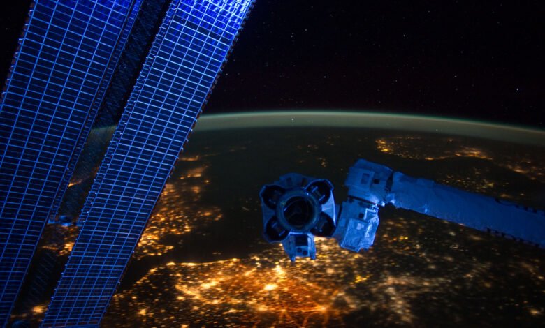
When you look at Earth from space at night, the planet transforms into a glowing network of lights. NASA City Lights Cities sparkle like constellations, highways form bright veins across continents, and entire regions glow with human activity. These stunning images are often referred to as NASA city lights, and they are far more than beautiful photographs. They provide scientists with valuable data about urban growth, energy use, economic activity, and even natural disasters.
Organizations like NASA have spent decades studying the Earth from space. By capturing nighttime imagery, scientists can observe patterns that are impossible to see from the ground. From population density to power outages, city lights tell a powerful story about how humans shape the planet.
In this article, we will explore what NASA city lights are, how they are captured, why they matter, and how researchers use them to understand our rapidly changing world.
What Are NASA City Lights?
NASA city lights refer to satellite images that show the Earth illuminated by artificial lights at night. These lights come from cities, towns, highways, ships, oil platforms, and other human-made sources of illumination. When satellites orbit the planet during nighttime hours, their sensors detect these lights and record them in remarkable detail.
One of the main instruments responsible for these images is the Visible Infrared Imaging Radiometer Suite, often called VIIRS. This instrument flies aboard the Suomi NPP satellite and captures extremely sensitive measurements of light from Earth’s surface. Unlike earlier systems, VIIRS can detect very faint lights, including small villages or fishing boats.
The resulting imagery often becomes part of the famous Earth at Night maps published by NASA and NOAA. These maps stitch together thousands of images to create a global nighttime portrait of our planet.
What makes NASA city lights so fascinating is that they reveal human presence from space. Even without political borders or labels, you can instantly recognize major urban areas such as Tokyo, New York, or Paris simply by the density of their lights.
The Technology Behind Nighttime Satellite Images
Capturing city lights from space is not as simple as pointing a camera at Earth. Nighttime imaging requires highly specialized sensors capable of detecting very small amounts of light. These sensors must also distinguish between different light sources, such as city lights, moonlight, and natural phenomena.
The VIIRS instrument aboard the Suomi NPP satellite includes a special channel called the Day/Night Band. This sensor is sensitive enough to detect light from a single streetlamp under ideal conditions. It can also capture faint natural light sources such as airglow and reflected moonlight.
Another challenge is filtering out unwanted signals. For example, clouds can reflect moonlight and appear bright in images. Scientists use complex algorithms to remove these effects and isolate artificial lighting.
Data from these satellites is processed and combined into large datasets by organizations like NASA and NOAA. Researchers then analyze the information to study patterns in human activity around the world.
Why NASA City Lights Matter
At first glance, NASA city lights may seem like beautiful space photography. However, scientists use these images as powerful tools to understand how societies grow and change. Nighttime lights can reveal patterns of urban development that traditional data sources may miss.
For example, when a city expands, new neighborhoods and infrastructure require lighting. Satellites quickly detect these new lights, allowing researchers to measure urban growth almost in real time. This is particularly useful in regions where reliable population data may be limited.
Nighttime imagery also provides insight into energy consumption. Brighter regions often correlate with higher electricity usage and economic development. By studying these patterns, policymakers can better understand global energy trends.
Another important application is disaster monitoring. When earthquakes, hurricanes, or conflicts disrupt electricity networks, city lights suddenly disappear. Satellites can detect these outages, helping emergency responders assess the situation quickly.
Mapping Urban Growth Around the World
One of the most fascinating uses of NASA city lights is tracking the expansion of cities. Over the past few decades, urban areas have grown rapidly, especially in developing regions. Satellite imagery makes it possible to observe this growth from a global perspective.
Researchers compare nighttime images from different years to see where new lights appear. These new lights often indicate new housing developments, industrial zones, or transportation infrastructure. Over time, small clusters of lights can evolve into large metropolitan areas.
This type of analysis has been particularly useful in countries experiencing rapid economic growth. For instance, many cities in Asia have expanded dramatically in recent decades, and their bright nighttime signatures clearly show this transformation.
Urban planners and policymakers rely on these insights to plan infrastructure, transportation, and energy distribution. By understanding where cities are growing, governments can make better decisions about future development.
Understanding Economic Activity Through Light
Believe it or not, the brightness of a region at night can reveal clues about its economic health. Economists have discovered strong correlations between nighttime light intensity and economic productivity.
Regions with strong economies tend to have extensive infrastructure, industries, and commercial districts that remain illuminated throughout the night. In contrast, less developed areas often show fewer or dimmer lights.
Researchers use NASA city lights data to estimate economic activity in places where official statistics may be incomplete or unreliable. By analyzing changes in brightness over time, they can track economic growth or decline.
This method has become a valuable tool for international organizations studying global development. Nighttime satellite imagery provides an independent way to measure economic trends across different countries.
Monitoring Disasters and Power Outages
Another powerful application of NASA city lights is disaster response. When natural disasters strike, electricity infrastructure is often damaged, leading to widespread power outages. Satellites can quickly detect these changes in nighttime illumination.
For example, after major hurricanes or earthquakes, scientists analyze city lights images to identify areas where power has been lost. This information helps emergency teams prioritize relief efforts and allocate resources more effectively.
Nighttime imagery can also reveal the impact of wildfires, floods, and other environmental events. In some cases, satellites detect temporary lights from emergency operations or recovery activities.
By providing near real-time information, NASA city lights have become an important tool for humanitarian response and disaster management.
Light Pollution and Environmental Impact
While city lights are a symbol of human progress, they also highlight an environmental concern: light pollution. Excessive artificial lighting disrupts natural ecosystems and affects wildlife behavior.
Many animals rely on darkness for navigation, feeding, and reproduction. Bright urban environments can confuse birds, insects, and sea turtles, leading to serious ecological consequences.
Scientists studying light pollution use nighttime satellite data to identify regions where artificial lighting is expanding rapidly. These insights help environmental groups advocate for smarter lighting practices.
Cities around the world are beginning to adopt solutions such as shielded streetlights, energy-efficient LEDs, and lighting curfews. These strategies reduce unnecessary illumination while still maintaining safety and visibility.
The Beauty of Earth at Night
Beyond its scientific value, NASA city lights imagery is simply breathtaking. When you view the Earth at night from space, you see a glowing portrait of humanity’s presence on the planet.
Famous images like the Black Marble maps created by NASA show the entire globe illuminated by billions of lights. Major cities shine brightly, while rural regions remain dark, creating striking visual contrasts.
These images remind us how interconnected our world has become. Highways link cities, ports glow along coastlines, and shipping routes appear as dotted lines across oceans.
For many people, these images also inspire a sense of unity. When viewed from space, political borders disappear, and humanity appears as one global community sharing a single planet.
The Future of Nighttime Earth Observation
Technology continues to improve, and the future of nighttime satellite observation looks incredibly promising. New sensors will be able to capture even finer details of Earth’s illuminated landscape.
Future missions from organizations like NASA aim to improve the resolution and accuracy of nighttime data. These advancements will help scientists monitor urban growth, environmental change, and global development more effectively.
Artificial intelligence is also playing a growing role in analyzing satellite imagery. Machine learning systems can quickly process vast amounts of data, identifying patterns and changes that humans might miss.
As our planet becomes more urbanized, NASA city lights will remain an essential tool for understanding how human activity shapes the Earth.
Conclusion
NASA city lights offer a fascinating glimpse into the rhythms of life on Earth. What appears to be a simple nighttime photograph actually contains a wealth of information about human civilization. From tracking urban expansion to monitoring disasters, these glowing patterns provide valuable insights for scientists, policymakers, and researchers.
Thanks to advanced satellites like the Suomi NPP satellite and the work of organizations such as NASA and NOAA, we can observe our planet in ways that were once impossible.
Perhaps the most powerful message hidden in these images is how connected humanity truly is. Every glowing city, every illuminated highway, and every distant fishing boat contributes to the brilliant tapestry of lights that surrounds our world each night.